|
MapCatalog | Order | Support | SiteIndex | Contact | Home | ||||||||||
|
|
|
|
|
|
|
|||||||||||
| MH Maps | Tech Spec | Download | License | Showcase | Reviews | |||||||||||
|
MapCatalog | Order | Support | SiteIndex | Contact | Home | ||||||||||
|
|
|
|
|
|
|
|||||||||||
| MH Maps | Tech Spec | Download | License | Showcase | Reviews | |||||||||||
Reprinted from Macworld - August 1997
Comprehensive CD collection of bitmap and vector maps
Mountain High Maps 2.5
Publisher:Digital Wisdom (800-800-8560) Price:$95, upgrade from previous version $45. Pros: up-to-date, comprehensive coverage, accurate. Cons: expensive if you only need one or two maps, source files for animation of limited use. Star ratings:
Shipping on four CDs, Mountain High Maps 2.5 has over 7,500 map files, covering just about every area of the globe you could wish for in Photoshop, Freehand and Illustrator format. Unlike other collections, all the maps can be used without having to pay an additional licence fee.
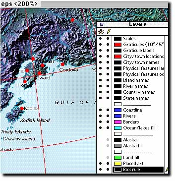
The FreeHand and Illustrator files have been improved in Version 4.0 and now include closed, pre-filled outline paths making custimzation much easier. The vector maps contain information on several layers including a total of 16,000 place names and labelled features. The layering system has been sensibly organized giving access to a good range of map elements without being too complex.
The most stunning images are the bitmap files. Here as well as individual country information, fully-coloured political and physical maps are available. Prior to this release most of the maps shipped as greyscale images and had to be coloured by the user. Information can be aded to bitmap files with the Photoshop path files included for each map. This is a very efficient way to include detail on your maps as the files are stored separately, path files reflect the layer structure in the vector files. Bitmap images are supplied as both 300 dpi for final use in printed work, and 72 dpi for positionals and for use in electronic printing.
The set of globe views is extensive, with each referenced by its longitude and latitude. They are supplemented by a set of animated files showing rotating globes. These are saved as QuickTime movies for inclusion in multimedia projects. Models and textures used have also been included on the CD. Each animation file is clearly marked with its duration, size, frame rate and colour depth.
Each CD covers a different geographical area, which makes finding the image you want quick and easy. As with any product of this type, redundancy of information can be a problem and as CD's are not available individually you may find there are some you never use. That said, the time and effort you'll save using these files means you'll soon recoup your investment.
Digital Wisdom has included comprehensive electronic manuals on each CD as well as extras such as vector arrows for use in Illustrator or FreeHand, Photoshop colour files and a QuarkXPress library containing a set of map-marker pins. The first CD contains a catalogue detailing the maps available as well as licence information on their use. It's hard to imagine anyone who uses map data finding a much better resource than Mountain High Maps.-Richard Spohrer
Any comments or problems with this
site? Please
let us know
- thank you!
© Digital Wisdom, Inc.