|
MapCatalog | Order | Support | SiteIndex | Contact | Home | ||||||||||
|
|
|
|
|
|
|
|||||||||||
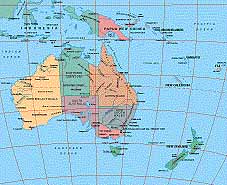
| Australasia | 401 | |||||||||||||||

Mountain High Maps Catalog - Australasia
Map Specifications for Australasia
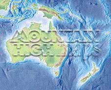
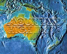
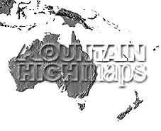
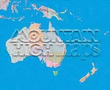
| Map identification: | 401 | Projection system: | Lambert's equal-area |
| Map coverage: | Australasia | North boundary: | 03° 00' N |
| Image size (pixels): | 2,589 x 2,109 pixels | South boundary: | 52° 00' S |
| Image size (inches): | 8.63 x 7.03 inches | East boundary: | 172° 00' W |
| Image size (metric): | 219 x 179 millimeters | West boundary: | 112° 00' E |
| Resolution per pixel: | 2,900 meters | Horizontal scale: | 1:6,336,000 |
| RGB file size: | 15.6 Mb | Vertical scale: | 1:328,333 |
| CMYK file size: | 20.9 Mb | Vertical interval: | 100 meters |
| Grayscale file size: | 5.2 Mb | Vertical exaggeration: | 19.3 times normal |
|
Countries, states and territories: |
Australia, Fiji, Indonesia, New Caledonia, New Zealand, Papua, New Guinea, Solomon Islands, Vanuatu, |
||
|
| ||
|
| ||
|
Top left: Elevation low-contrast relief rendering Top right: Vegetation high-contrast relief rendering Middle left: Grayscale land-only relief rendering Middle right: Political low-contrast relief rendering Lower right: Geo-political vector Illustrator EPS maps Inventory of maps and masks within each map portfolio
|
 |

| Australasia Map #401 - Buying Options |
||||||||
|
Australasia Continent Vector only EPS map (bottom left map image) |
Australasia Continent Relief/Vector Map (all maps on this page) |
Australasia Continent Relief/Vector 4 Map Package |
Mountain High Maps Relief/Vector 78 Map Package | |||||
Any comments or problems with this
site? Please
let us know - thank you!
© Digital Wisdom, Inc.