|
MapCatalog | Order | Support | SiteIndex | Contact | Home | ||||||||||
|
|
|
|
|
|
|
|||||||||||
| Europe | Brit. Isles | 515 | ||||||||||||||

Mountain High Maps Catalog - Scotland, N. Ireland, N. England
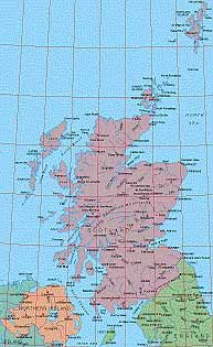
Map Specifications for Scotland, N. Ireland, N. England
| Map identification: | 515 | Projection system: | Conical |
| Map coverage: | Scotland, N. Ireland, N. England | North boundary: | 61° 00' N |
| Image size (pixels): | 1,648 x 2,701 pixels | South boundary: | 54° 00' N |
| Image size (inches): | 5.49 x 9.00 inches | East boundary: | 00° 00' to 01° 00' W |
| Image size (metric): | 139 x 229 millimeters | West boundary: | 08° 00' W |
| Resolution per pixel: | 300 meters | Horizontal scale: | 1:1,000,000 |
| RGB file size: | 12.6 Mb | Vertical scale: | 1:100,000 |
| CMYK file size: | 16.9 Mb | Vertical interval: | 30 meters |
| Grayscale file size: | 4.2 Mb | Vertical exaggeration: | 10.0 times normal |
|
Countries, states and territories: |
England, Northern Ireland, Scotland, |
||
|
| ||
|
| ||
|
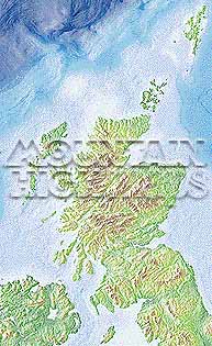
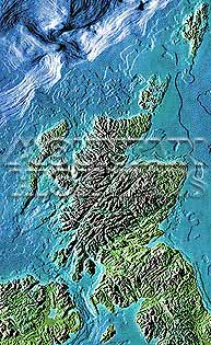
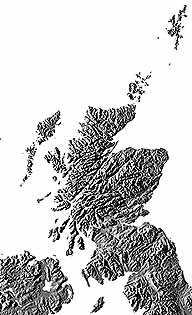
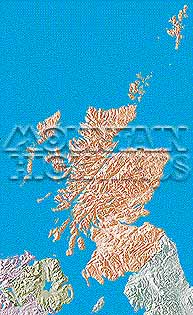
Top left: Elevation low-contrast relief rendering Top right: Vegetation high-contrast relief rendering Middle left: Grayscale land-only relief rendering Middle right: Political low-contrast relief rendering Lower right: Geo-political vector Illustrator EPS maps Inventory of maps and masks within each map portfolio
|
 |

| Scotland Map #515 - Buying Options |
||||||||
|
Scotland Vector only EPS map (bottom left map image) |
Scotland Relief/Vector Map (all maps on this page) |
Europe Continent Relief/Vector 23 Map Package |
Mountain High Maps Relief/Vector 78 Map Package | |||||
Any comments or problems with this
site? Please
let us know
- thank you!
© Digital Wisdom, Inc.