|
MapCatalog | Order | Support | SiteIndex | Contact | Home | ||||||||||
|
|
|
|
|
|
|
|||||||||||
| Geocart | Projection | Databases | Download | Demo | ||||||||||||


Geocart® Version 2.6, the Macintosh map projection program
|
MapCatalog | Order | Support | SiteIndex | Contact | Home | ||||||||||
|
|
|
|
|
|
|
|||||||||||
| Geocart | Projection | Databases | Download | Demo | ||||||||||||
Digital Chart of the World for GeocartGTOPO30 database for Geocart
The Digital Chart of the World is a set of comprehensive 1: 1 million scale vector databases covering the entire world. The data, over 800 MB on two CD-ROMs, include coastlines, international boundaries, contours, major road and rail networks, major drainage systems and major utility networks (cross-country pipelines and communication lines). The included CropDataBase program allows you to extract just the data you need so that Geocart will work with maximum speed. For a full list of the Geocart DCW database, check the DCW features contents page.
$2,000.00 National Atlas database for Geocart
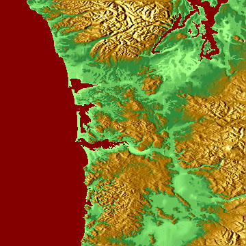
GTOPO30 is a global digital elevation model with elevation points regularly spaced at 30-arc seconds (approximately 1 kilometer) for all of the Earth's land surface. It is 120 pixels per degree producing a 2.6 gigabyte database on 3 CDROMs. The database comes with a program called TOPOtoIMAGE that will translate GTOPO30 into Geocart Image databases. The program allows you to color the GTOPO30 databases with one of over a thirty pre-set "gradients" or create your own.
$750.00
World Data Bank II coastlines
National Atlas Digital databases allow you to create an entire map quickly and easily. Save time and money by using Geocart to plot all of the data automatically, in the right place. When used together, the National Atlas Digital Databases contain all of the information needed to create detailed maps of the US, including roads, rivers, boundaries, cities, counties and type. There are 5 distinct 1:2,000,000 scale U.S. databases:
SAVE: Buy all 5 databases for $900
Roads, Drainage and Counties - Plot highways, roads, streams, lakes and more. The built in classifications make it easy to quickly establish a hierarchy when building base maps. Includes all major roads as classified by the US Dept of Transportation. For the 48 continental states plus Hawaii. Can be used in conjunction with the National Atlas Labels (below) if names are desired. Features 6 road classifications that match US Dept. of Transportation categories, railroads, 15 water classifications including rivers, swamps, lakes and dry lakes, and detailed county and state boundaries. Source: Digital National Atlas, USGS, 1995
$300.00 National Atlas Labels 37 categories of physical and cultural feature names let you plot just the information you need on your map. Can be modified to create any font style or size needed. Includes all US states and territories. Includes city and town names, county names, county seat names, lake and river names, points of interest, and over 40,000 labels, most with elevations. Source: The United States Gazetteer, USGS, 1990
$200.00 Federal Land Boundaries 59 separate categories of Federal Lands. Plot all of the categories at once or choose only the ones needed in areas as small as 1/2 square mile. For the 48 continental states plus Hawaii. Includes 59 Categories of Federal Land Management, county and state boundaries, National Parks, National Forests, BLM Land, Dept of Defense, Fish & Wildlife plus many more. Source: Digital National Atlas, USGS, 1995
$300.00 1994 Census Data Plot cities by population easily and quickly. Population is broken down into 10 categories. Each population category is automatically plotted as a different font size and style which can easily be changed by the user. Also includes a separate data file sorted by population so you can create your own population breaks using any text editor. For all US states and Puerto Rico. Includes city and town names, built-up metro areas, and 23,600 populated place names. Source: US Census Bureau, 1995
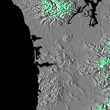
$250.00 Grayscale USA 120 The Grayscale USA 120 contains shading, elevations and a water mask. The resolution of this file is 120 pixels per degree. Extends from 66° W to 126° W and 24° N to 50° N.
$280.00 Altitude Color 12
This file is a high resolution coastline database with a nominal scale of 1:2,000,000 (about 5 times the resolution of the database that is included with Geocart). The file, supplied on a CD-ROM disk, is 22 MB.
$300.00 Color Relief 12
The Altitude Color database is a color map of the Earth with land and water shading based upon the altitude. On land, the lower altitudes are light green moving to dark green, brown and then white at higher altitudes. Deep water is shaded dark blue and shallow water is shaded a medium blue. The resolution of this file is 12 pixels per degree. The file size is 26.7 MB and it comes on a CD-ROM disk. An 8 pixels per degree database and an image cropping program are also included.
$250.00 Political World 12
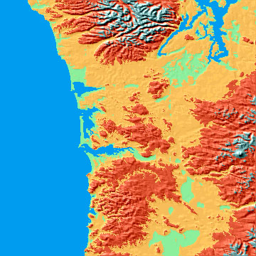
The Color Relief database is a color map of the Earth with highlights and shadows on the land and ocean floor. The resolution of this file is 12 pixels per degree. The file size is 26.7 MB and it comes on a CD-ROM disk. An 8 pixels per degree database and an image cropping program are also included.
$250.00 Grayscale World 12
The Political World database is a color map of the Earth with each country colored separately. The resolution of this file is 12 pixels per degree. The file size is 26.7 MB and it comes on a CD-ROM disk. An 8 pixels per degree database and an image cropping program are also included.
$250.00 TerrainBase 12
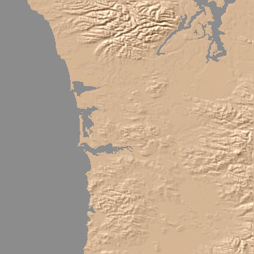
The Grayscale databases store 3 separate grayscale images in each of the 3 color channels. Channel 1 contains a Grayscale image in which the Earth's topography is represented by different shades of gray. The higher the area the lighter the color. Channel 2 contains a shaded relief image of the Earth's land and ocean depths. This image can be used to add shaded topography to your maps. Channel 3 contains a mask for separating water from land. The resolution of this file is 12 pixels per degree. The file size is 26.7 MB and it comes on an CD-ROM disk. An 8 pixels per degree database and an image cropping program are also included.
$250.00 Grayscale USA 120
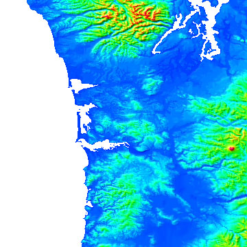
This is the database to use if you want to create your own color maps. Similar to the Grayscale databases, this database has improved accuracy. Use it to create stunning color relief images of the earth's land and ocean depths. Included with this database are example maps and a detailed discussion of how to produce your own color images. Channel 1 represents the earth's land with different shades of gray. The higher the area the lighter the color. Channel 2 contains the ocean floor. Channel 3 contains a mask for separating water from land. The resolution of this file is 12 pixels per degree. The file size is 26.7 MB and it comes on an CD-ROM disk. An 8 pixels per degree database and an image cropping program are also included.
$250.00 Living Earth 12
The Grayscale USA databases store 3 separate grayscale images in each of the 3 color channels. Channel 1 contains a Grayscale image in which the U.S. topography is represented by different shades of gray. The higher the area the lighter the color. Channel 2 contains a shaded relief image of the U.S. This image can be used to add shaded topography to your maps. Channel 3 contains a mask for separating water from land. The resolution of this file is 120 pixels per degree. The image extends from 126°W to 66°W and from 50°N to 24°N. The file size is 64 MB and it comes on an CD-ROM disk. An image cropping program is also included.
$280.00
The Living Earth database is an enhanced satellite photomosaic of the Earth. The resolution of this file is 12 pixels per degree. The file size is 26.7 MB and it comes on an CD-ROM disk. An 8 pixels per degree database and an image cropping program are also included. Use of this file is limited to non-commercial purposes only. Separate permission must be purchased for each commercial usage. For information on commercial usage please contact us.
$250.00
Any comments or problems with this
site? Please
let us know
- thank you!
© Digital Wisdom, Inc.